
4Resilience
The 4Resilience, developed by ADPC, is a centralized platform that provides access to advanced geospatial data and tools for disaster risk reduction and climate resilience. This portal is designed to support governments, humanitarian organizations, researchers, and communities in making informed decisions to prepare for and respond to disaster risks more effectively.
ADPC’s geospatial tools were originally developed to support Southeast Asian countries in addressing climate risks, disasters, and environmental challenges. Southeast Asia faces increasing risks from floods, droughts, cyclones, wildfires, and landslides due to climate change and rapid urbanization. Timely and data-driven decision-making is critical to reducing the impact of these disasters.
Hence, developed geospatial tools provide critical data and insights tailored to the Southeast Asian region’s needs. However, upon request from other countries or organizations, ADPC scientists can expand the scope and coverage of these geospatial tools to support decision-making in other regions.
This flexibility ensures that the geospatial tools remain adaptable and responsive to emerging challenges, helping governments and stakeholders worldwide enhance disaster resilience and preparedness.
The 4Resilience helps bridge the gap between cutting-edge geospatial technology and real-world emergency preparedness, ensuring that stakeholders have the right tools and insights when they need most accurate data to take informed decisions.
The 4Resilience provides:
- Interactive maps and satellite-based analytics for hazard monitoring
- Access to satellite imagery, climate models, and disaster event records
- Forecasts for extreme weather events like typhoons, floods, and droughts
- Customizable dashboards or user-friendly visualizations for decision-makers and emergency responders
- Capacity building resources such as training materials, guides, and case studies on disaster preparedness
- Downloadable datasets and APIs for researchers and government agencies
About the Tools
The geospatial tools available on the 4Resilience were advanced as part of the SERVIR Southeast Asia program, supported by NASA and USAID from 2023-2024. These tools harness cutting-edge satellite data, Earth observation technologies, and geospatial analytics to enhance disaster risk resilience, environmental management, and climate adaptation.
NASA’s expertise in satellite remote sensing and climate modeling has been instrumental in developing tools that provide near real-time, science-based insights for decision-makers across Southeast Asia and beyond. NASA’s satellite data were integrated with local ground knowledge and needs, which allowed to empower governments, researchers, and communities to monitor hazards, assess risks, and strengthen climate resilience.

Southeast Asia Drought Watch (SEADW)
Droughts in Southeast Asia negatively impact ecosystem services, food and water security, and biodiversity. These impacts are exacerbated by climate change, further highlighting the need for improved governance and decision-making in virtually all sectors. Southeast Asia Drought Watch (SEADW) helps to improve the operational, technological, and institutional capabilities to prepare for and respond to droughts in the Southeast Asia region; to support local decision-makers in drought monitoring, analysis, and forecasting; and to provide policymakers and growers with current and forecast drought indices to facilitate decision-making within the current growing season.

Land and Agriculture Monitoring Project (LAMP)
SERVIR Southeast Asia developed the Land and Agriculture Monitoring Project (LAMP) tool in response to a need expressed by stakeholders, who require insight and reports on the effectiveness of biodiversity and conservation-related project interventions. LAMP is an open-access, web-based tool designed to monitor the landscape and biophysical conditions in Myanmar. The core features of this tool include maps, charts, and descriptive information to track various environmental parameters critical to environmental protection and safeguarding. This user manual provides guidance on how to navigate and effectively utilize the dashboard’s features.

Southeast Asia Air Quality Tracker
Air quality is becoming a critical challenge across Southeast Asia, with the World Health Organization estimating that 2 million of the 7 million global deaths from air pollution exposure occur in the region. The dry season during the Asian Monsoon, coupled with winter low temperatures and calm winds, allows pollutants to accumulate, degrading air quality. The harmful pollution experienced across Southeast Asia has driven the need for better air quality monitoring and public awareness. Building on the success of the Mekong Air Quality Explorer developed in collaboration with Thailand, the Air Quality Tracker expands these efforts to the entire Southeast Asia region. It allows users to monitor historical data, near real-time satellite observations, ground-based measurements, and forecasts in one integrated platform. In collaboration with NASA, the tool now provides air quality data at a 5km resolution and integrates new datasets from Korea’s GEMS. User-friendly yet scientifically robust, the Air Quality Tracker supports decision-makers across Southeast Asia in tracking air quality, detecting fires, and managing transboundary haze more effectively.
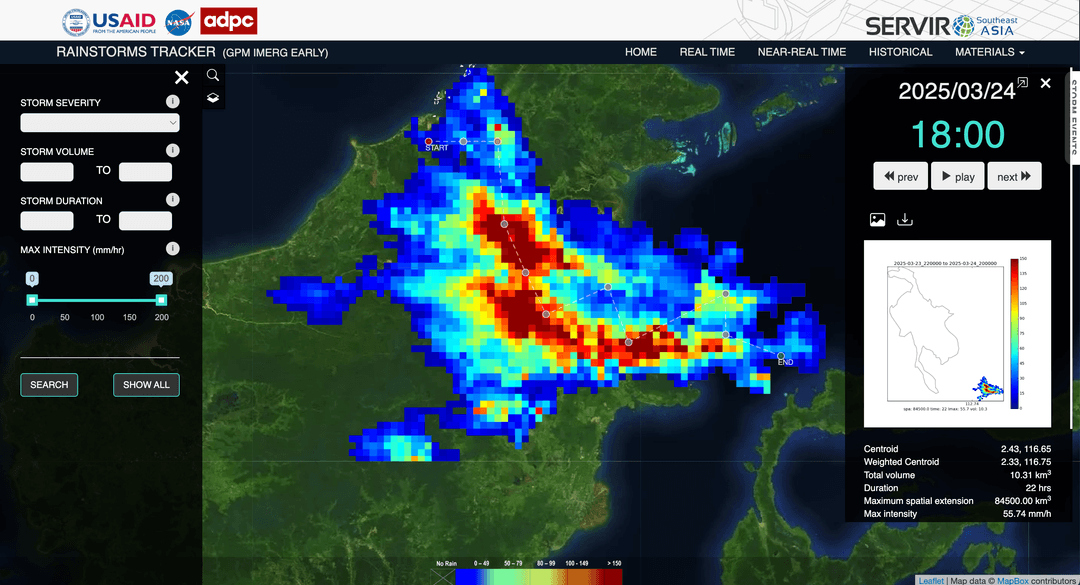
Rainstorm Tracker tool is an operational storm analyzer developed to monitor and alert authorities about the severity of rainstorm events over the Lower Mekong Basin in near-real-time. This system employs a 4D object-based recognition approach to track and evaluate the severity of storms detected by satellites. Using Rainstorm Tracker, regional organizations can improve the flash flood early warning capabilities thereby reducing risk.
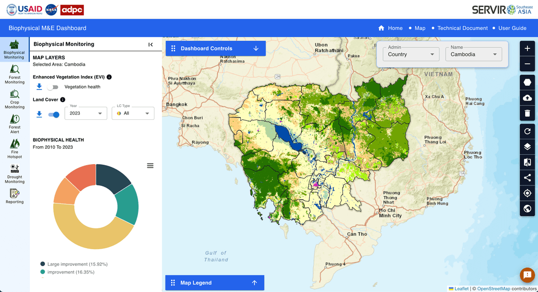
SERVIR Southeast Asia developed the Land and Agriculture Monitoring Project (LAMP) tool in response to a need expressed by stakeholders, who require insight and reports on the effectiveness of biodiversity and conservation-related project interventions. LAMP is an open-access, web-based tool designed to monitor the landscape and biophysical conditions in Myanmar. The core features of this tool include maps, charts, and descriptive information to track various environmental parameters critical to environmental protection and safeguarding. ThiBiophysical M&E Dashboard supports USAID, Cambodia in monitoring and managing large scale sustainable landscape management projects by using satellite data to determine landscape conditions before and after project intervention.
Our Partnership
Department Of Disaster Prevention And Mitigation Ministry Of Interior

Asian Institute of Technology
Mekong River Commission (MRC)
United Nations Office for Disaster Risk Reduction
Asian Institute of Technology
Mekong River Commission (MRC)